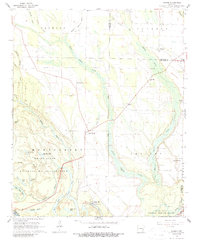
1967 Map of Turner
USGS Topo · Published 1988About this map
Indian Bay and the surrounding river bottomlands define this landscape in the late 1960s, where the convergence of the White River National Wildlife Refuge and numerous bayous created a complex network of waterways and wetlands. An ancient Indian Mound near the bay suggests long-standing human occupation of these fertile terraces. The settlement pattern is scattered across the ridge land between the Big Cypress Creek and Indian Bayou, anchored by small rural centers like Turner and Cross Roads.
Find a feature on this map
51 named features on this map. Tap any name to fly to it.
Don’t see what you’re looking for? This feature index may not catch every label — zoom into the map to look around manually.
Map Details
Editions of this 1967 Turner Map
2 editions found
Other maps of this area

1939 · Modoc
USGS Topo · 1:62,500

1939 · Indian Bay
USGS Topo · 1:62,500

1940 · Marvell
USGS Topo · 1:62,500

1940 · Holly Grove
USGS Topo · 1:62,500

1948 · Helena
USGS Topo · 1:250,000

1948 · Modoc
USGS Topo · 1:62,500

1950 · Helena
USGS Topo · 1:250,000

1954 · Indian Bay
USGS Topo · 1:62,500

1955 · Helena
USGS Topo · 1:250,000

1956 · Marvell
USGS Topo · 1:62,500