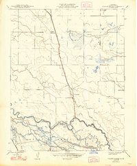
1948 Map of Turner Ranch
USGS Topo · Published 1948About this map
The San Joaquin River meanders through this Merced County landscape, its course defined by a complex network of waterways including Pick Anderson Slough and Salt Slough. The land use of the late 1940s is dominated by significant cattle ranching operations and water management systems. Named holdings such as Turner Ranch, Cranes Ranch, McNamara Ranch, and Hoagland Ranch are connected by a grid of rural tracks like Turner Road. Irrigation and water control are central to the region's geography, evidenced by the prominent East Side Canal and the Shearn Lateral. The southern portion of the map is defined by the Sanjon De Santa Rita boundary, where the river braids into multiple channels near the Bypass and Deep Slough. This survey preserves the hydraulic character of the Central Valley before mid-century agricultural intensification reshaped many of these smaller sloughs and creek beds.
Find a feature on this map
21 named features on this map. Tap any name to fly to it.
Don’t see what you’re looking for? This feature index may not catch every label — zoom into the map to look around manually.
Map Details
Editions of this 1948 Turner Ranch Map
This is the sole edition of this map. No revisions or reprints were ever made.
Other maps of this area

1916 · Santa Rita Bridge
USGS Topo · 1:24,000

1916 · Delta Ranch
USGS Topo · 1:24,000

1918 · Arena
USGS Topo · 1:31,680

1918 · Atwater
USGS Topo · 1:31,680

1918 · Stevinson
USGS Topo · 1:31,680

1918 · Sandy Mush
USGS Topo · 1:31,680

1918 · Turner Ranch
USGS Topo · 1:31,680

1919 · San Luis Ranch
USGS Topo · 1:31,680

1920 · Santa Rita Bridge
USGS Topo · 1:31,680

1921 · Los Banos
USGS Topo · 1:31,680