
1966 Map of Turon
USGS Topo · Published 1967About this map
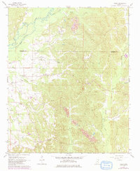
The Old Indian Treaty Boundary cuts a diagonal path across this landscape on the border of Itawamba Co and Monroe Co, marking a transition between the creek bottoms and the upland ridges. In the mid-1960s, the small settlements of Turon and Parham served as local anchors, surrounded by a dense network of family cemeteries and rural congregations. The terrain is defined by the winding course of Bull Mountain Creek and Hadaway Creek, where numerous Gravel Pits and a prominent Strip Mine near Weaver Creek indicate the area's extractive activity. Genealogists will find a high density of burial sites including Dyer Cem, Burdine Cem, and Pickle Cem. From the vantage of the Splunge Lookout Tower, the view would have encompassed the heavily wooded hills and the scattered homesteads connected by light-duty roads and field lines.
Find a feature on this map
36 named features on this map. Tap any name to fly to it.
Don’t see what you’re looking for? This feature index may not catch every label — zoom into the map to look around manually.
Map Details
Editions of this 1966 Turon Map
2 editions found
Other maps of this area

1953 · West Point
USGS Topo · 1:250,000

1956 · Tupelo
USGS Topo · 1:250,000

1958 · Tupelo
USGS Topo · 1:250,000

1958 · West Point
USGS Topo · 1:250,000

1963 · West Point
USGS Topo · 1:250,000

1966 · Smithville
USGS Topo · 1:24,000

1966 · Beans Ferry
USGS Topo · 1:24,000

1966 · Amory
USGS Topo · 1:24,000

1966 · Tremont
USGS Topo · 1:24,000

1966 · Greenwood Springs
USGS Topo · 1:24,000