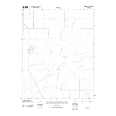
2010 Map of Turpin East
USGS Topo · Published 2010About this map
The Beaver River winds through the southern half of this landscape, carving a prominent path through the High Plains of the Oklahoma Panhandle. Near the northwest corner, the community of Turpin serves as a focal point for the region's transport, where local roads like Beaver Rd intersect with the primary north-south highway. The terrain is defined by several drainage systems, including Sharp Creek and Short Creek, which feed toward the river from the north, while Jackson Creek approaches from the south. The prevalence of grid-patterned roads, such as Hollow E0120 and Hollow N1210, illustrates the systematic land division and agricultural organization typical of this era. Further east along the creek beds, the Smith Ranch represents the rural ranching operations that have long anchored the local economy in this part of Beaver County.
Find a feature on this map
25 named features on this map. Tap any name to fly to it.
Don’t see what you’re looking for? This feature index may not catch every label — zoom into the map to look around manually.
Map Details
Editions of this 2010 Turpin East Map
This is the sole edition of this map. No revisions or reprints were ever made.
Other maps of this area

1954 · Perryton
USGS Topo · 1:250,000

1958 · Perryton
USGS Topo · 1:250,000

1973 · Balko
USGS Topo · 1:24,000

1973 · Boyd
USGS Topo · 1:24,000

1973 · Floris
USGS Topo · 1:24,000

1973 · Little Ponderosa
USGS Topo · 1:24,000

1973 · Turpin East
USGS Topo · 1:24,000

1973 · Red Horse Creek
USGS Topo · 1:24,000
1973 · Beaver NW
USGS Topo · 1:24,000
1973 · Turpin NE
USGS Topo · 1:24,000