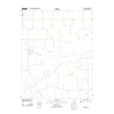
2012 Map of Turpin East
USGS Topo · Published 2012About this map
Turpin sits at the northwestern edge of this High Plains landscape, where the agricultural grid meets the winding course of the Beaver River. This 2012 survey illustrates the section-line road network that defines the region's ranching and farming layout, with routes like Beaver Rd and N1190 Rd providing structure to the open terrain. The drainage patterns are a primary focal point, showing how Short Creek, Sharp Creek, and Jackson Creek cut through the plains to feed into the river valley. The map offers a precise view of the local topography and water distribution in this corner of the Oklahoma Panhandle, which is essential for understanding the land use and hydrology of the area in the early 21st century.
Find a feature on this map
47 named features on this map. Tap any name to fly to it.
Don’t see what you’re looking for? This feature index may not catch every label — zoom into the map to look around manually.
Map Details
Editions of this 2012 Turpin East Map
This is the sole edition of this map. No revisions or reprints were ever made.
Other maps of this area

1954 · Perryton
USGS Topo · 1:250,000

1958 · Perryton
USGS Topo · 1:250,000

1973 · Balko
USGS Topo · 1:24,000

1973 · Boyd
USGS Topo · 1:24,000

1973 · Floris
USGS Topo · 1:24,000

1973 · Little Ponderosa
USGS Topo · 1:24,000

1973 · Turpin East
USGS Topo · 1:24,000

1973 · Red Horse Creek
USGS Topo · 1:24,000
1973 · Beaver NW
USGS Topo · 1:24,000
1973 · Turpin NE
USGS Topo · 1:24,000