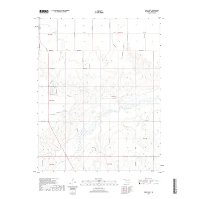
2018 Map of Turpin East
USGS Topo · Published 2018About this map
Beaver River meanders across the southern plains of the Oklahoma Panhandle in this 2018 survey of eastern Beaver County. The landscape is defined by the broad drainage basin of the river and its seasonal tributaries, including Sharp Cr and Jackson Creek. The survey reflects the rectilinear geometry of the Public Land Survey System, with township and range lines like t4n r21e and t5n r21e forming the primary framework for land organization and rural access roads. Modern infrastructure is represented by a grid of local routes such as Beaver Rd, Ew 13, and Ew 17, which provide access to the vast ranching and agricultural tracts between the river breaks and the higher tablelands. This map captures the characteristic hydrological patterns of the High Plains, where drainage channels often remain dry except during significant weather events.
Find a feature on this map
43 named features on this map. Tap any name to fly to it.
Don’t see what you’re looking for? This feature index may not catch every label — zoom into the map to look around manually.
Map Details
Editions of this 2018 Turpin East Map
This is the sole edition of this map. No revisions or reprints were ever made.
Other maps of this area

1954 · Perryton
USGS Topo · 1:250,000

1958 · Perryton
USGS Topo · 1:250,000

1973 · Balko
USGS Topo · 1:24,000

1973 · Boyd
USGS Topo · 1:24,000

1973 · Floris
USGS Topo · 1:24,000

1973 · Little Ponderosa
USGS Topo · 1:24,000

1973 · Turpin East
USGS Topo · 1:24,000

1973 · Red Horse Creek
USGS Topo · 1:24,000
1973 · Beaver NW
USGS Topo · 1:24,000
1973 · Turpin NE
USGS Topo · 1:24,000