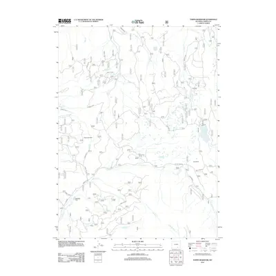
2012 Map of Turpin Reservoir
USGS Topo · Published 2012About this map
Turpin Reservoir and its surrounding watershed define this high-country landscape in the southern Medicine Bow Mountains. The area is characterized by a complex network of forest access routes, including Forest Rd 100 and Forest Rd 201, which navigate a series of high-altitude clearings and meadows known locally as parks. Significant landmarks such as Fish Creek Park, Cecil Park, and Mullison Park appear as distinct openings within the timber. The drainage pattern is intricate, with headwaters for Turpin Cr, N Brush Cr, and Cassidy Cr flowing through the terrain. The presence of Murky Lake and numerous smaller water bodies north of the reservoir illustrates the saturated nature of these alpine basins during the early 21st century.
Find a feature on this map
28 named features on this map. Tap any name to fly to it.
Don’t see what you’re looking for? This feature index may not catch every label — zoom into the map to look around manually.
Map Details
Editions of this 2012 Turpin Reservoir Map
This is the sole edition of this map. No revisions or reprints were ever made.
Other maps of this area

1893 · Fort Steele
USGS Topo · 1:125,000

1906 · Medicine Bow
USGS Topo · 1:125,000

1908 · Medicine Bow
USGS Topo · 1:125,000

1939 · Saratoga
USGS Topo · 1:125,000

1954 · Rawlins
USGS Topo · 1:250,000

1955 · Elk Mountain SW
USGS Topo · 1:24,000

1955 · Coad Mountain
USGS Topo · 1:24,000

1958 · Rawlins
USGS Topo · 1:250,000

1958 · White Rock Canyon
USGS Topo · 1:24,000

1961 · Ryan Park
USGS Topo · 1:24,000