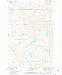
1961 Map of Turtle Creek NE
USGS Topo · Published 1980About this map
Glacial potholes and prairie wetlands define this rural McLean County landscape as it appeared in the early 1960s. The region is largely defined by the agricultural and educational infrastructure of the period, anchored by institutions like the Koenig Sch No 1 and South St Olaf Ch. A significant water feature, the Canal, cuts across the southern portion of the quadrangle, reflecting mid-century water management efforts associated with the Missouri River Basin development.
Find a feature on this map
8 named features on this map. Tap any name to fly to it.
Don’t see what you’re looking for? This feature index may not catch every label — zoom into the map to look around manually.
Map Details
Editions of this 1961 Turtle Creek NE Map
2 editions found

Other maps of this area

1945 · Pelican Lake
USGS Topo · 1:62,500

1947 · Pelican Lake
USGS Topo · 1:62,500

1947 · Turtle Lake
USGS Topo · 1:62,500

1949 · Turtle Creek
USGS Topo · 1:62,500

1954 · McClusky
USGS Topo · 1:250,000

1958 · McClusky
USGS Topo · 1:250,000

1959 · Mercer
USGS Topo · 1:24,000

1959 · Mercer SW
USGS Topo · 1:24,000

1961 · Turtle Creek SW
USGS Topo · 1:24,000

1961 · Turtle Lake
USGS Topo · 1:24,000