
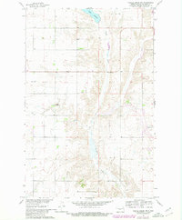
1961 Map of Turtle Creek NW
USGS Topo · Published 1963About this map
Turtle Creek meanders through this agricultural section of McLean County, its course punctuated by a Gaging Station and the waters of Lake Ordway in the northern reach. The landscape reflects a pattern of rural settlement typical of the early 1960s, defined by section lines and small community centers. Local life is anchored at the crossroads where the Veeder Ch and Veeder School No 2 stand, serving the surrounding farmsteads. Surveyed as part of the Department of the Interior's Missouri River Basin development program, the map documents a precise moment in North Dakota's mid-century rural infrastructure before further consolidation changed the footprint of local country schools and parishes.
Find a feature on this map
5 named features on this map. Tap any name to fly to it.
Don’t see what you’re looking for? This feature index may not catch every label — zoom into the map to look around manually.
Map Details
Editions of this 1961 Turtle Creek NW Map
2 editions found
Other maps of this area

1929 · Coleharbor
USGS Topo · 1:62,500

1947 · Turtle Lake
USGS Topo · 1:62,500

1949 · Turtle Creek
USGS Topo · 1:62,500

1949 · Washburn
USGS Topo · 1:62,500

1954 · McClusky
USGS Topo · 1:250,000

1958 · McClusky
USGS Topo · 1:250,000

1961 · Turtle Creek SW
USGS Topo · 1:24,000

1961 · Turtle Lake
USGS Topo · 1:24,000

1961 · Lake Nettie
USGS Topo · 1:24,000

1961 · Washburn
USGS Topo · 1:24,000