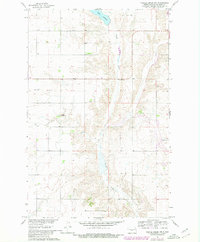
1961 Map of Turtle Creek NW
USGS Topo · Published 1980About this map
Turtle Creek meanders through the heart of this McLean County landscape, illustrating a rural prairie environment undergoing modern hydraulic development during the mid-20th century. Mapped as part of the Department of the Interior program for the Missouri River Basin, the topography reveals the transition between natural watercourses and engineered irrigation infrastructure, such as the prominent Canal cutting across the northern sections. Evidence of established local communities appears through family-named landmarks like Veeder Ch and the Veeder School No 2, providing essential coordinates for genealogical research in this part of North Dakota. In the northern reaches, Lake Ordway stands as a significant water body, while a Gaging Station on the creek indicates the era's focus on water management and streamflow monitoring.
Find a feature on this map
7 named features on this map. Tap any name to fly to it.
Don’t see what you’re looking for? This feature index may not catch every label — zoom into the map to look around manually.
Map Details
Editions of this 1961 Turtle Creek NW Map
2 editions found

Other maps of this area

1929 · Coleharbor
USGS Topo · 1:62,500

1947 · Turtle Lake
USGS Topo · 1:62,500

1949 · Turtle Creek
USGS Topo · 1:62,500

1949 · Washburn
USGS Topo · 1:62,500

1954 · McClusky
USGS Topo · 1:250,000

1958 · McClusky
USGS Topo · 1:250,000

1961 · Turtle Creek SW
USGS Topo · 1:24,000

1961 · Turtle Lake
USGS Topo · 1:24,000

1961 · Lake Nettie
USGS Topo · 1:24,000

1961 · Washburn
USGS Topo · 1:24,000