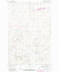
1980 Map of Turtle Creek SE
USGS Topo · Published 1980About this map
Painted Woods Creek meanders across the southern portion of this McLean County landscape, defined by a rural network of family-run school districts and small country congregations. Based on surveys from 1958 and 1961 with 1980 updates, the map documents a stable agricultural community where local life centered around rural schoolhouses like Koenig Sch No 4 and Park Sch No 3. These numbered schools, along with Iowa Sch No 2 and Iowa Sch No 3, illustrate the historical density of the rural education system before mid-century consolidation. The presence of Zion Cem and Fairview Ch suggests the early anchors of the township's social and religious life. A Gaging Station and a Gravel Pit indicate the modest industrial and infrastructure footprints of the Missouri River Basin development program during this era.
Find a feature on this map
11 named features on this map. Tap any name to fly to it.
Don’t see what you’re looking for? This feature index may not catch every label — zoom into the map to look around manually.
Map Details
Editions of this 1980 Turtle Creek SE Map
This is the sole edition of this map. No revisions or reprints were ever made.
Other maps of this area

1949 · Turtle Creek
USGS Topo · 1:62,500

1950 · Wilton
USGS Topo · 1:62,500

1954 · McClusky
USGS Topo · 1:250,000

1958 · McClusky
USGS Topo · 1:250,000

1959 · Mercer
USGS Topo · 1:24,000

1959 · Mercer SW
USGS Topo · 1:24,000

1961 · Turtle Creek SW
USGS Topo · 1:24,000

1961 · Turtle Creek NE
USGS Topo · 1:24,000

1961 · Turtle Creek NW
USGS Topo · 1:24,000

1961 · Turtle Creek SE
USGS Topo · 1:24,000