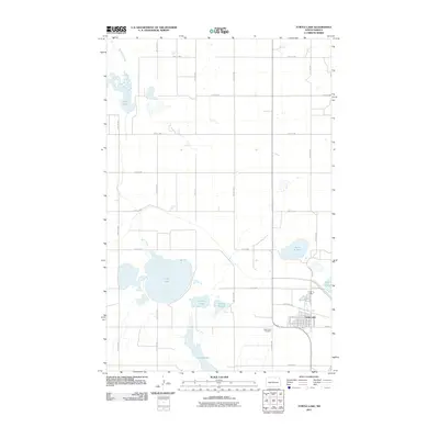
2011 Map of Turtle Lake
USGS Topo · Published 2011About this map
The town of Turtle Lake serves as the focal point of this McLean County survey, situated at a junction of local roads including County Rd 12 and Burke St. The landscape is defined by an extensive network of prairie wetlands and basins, dominated by the large body of Turtle Lake and the nearby Lake Brekken. This area reflects the glacial topography of the region, where water bodies like Brittons Slough, Mud Lake, and Hanson Slough are scattered across a grid of section-line roads. On the southern edge of the main settlement, the Turtle Lake Cemetery sits along the road network. The drainage pattern is further illustrated by the winding course of Turtle Creek, which meanders through the western portion of the quadrangle. This 2011 survey captures the town and its surrounding agricultural landscape before significant modern alterations, showing the relationship between the rural community and its critical water resources.
Find a feature on this map
24 named features on this map. Tap any name to fly to it.
Don’t see what you’re looking for? This feature index may not catch every label — zoom into the map to look around manually.
Map Details
Editions of this 2011 Turtle Lake Map
This is the sole edition of this map. No revisions or reprints were ever made.
Other maps of this area

1929 · Coleharbor
USGS Topo · 1:62,500

1947 · Turtle Lake
USGS Topo · 1:62,500

1949 · Turtle Creek
USGS Topo · 1:62,500

1949 · Washburn
USGS Topo · 1:62,500

1954 · McClusky
USGS Topo · 1:250,000

1958 · McClusky
USGS Topo · 1:250,000

1961 · Turtle Lake
USGS Topo · 1:24,000

1961 · Lake Nettie
USGS Topo · 1:24,000

1961 · Turtle Creek NE
USGS Topo · 1:24,000

1961 · Washburn NE
USGS Topo · 1:24,000