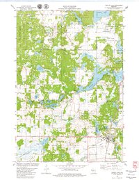
1978 Map of Turtle Lake
USGS Topo · Published 1979About this map
The village of Turtle Lake serves as a critical transportation hub in the late 1970s, where the Chicago and North Western and Soo Line railroads intersect near Old Mill Pond. This map details a landscape defined by glacial activity, featuring a dense network of kettle lakes and wetlands including Horseshoe Lake, Staples Lake, and the expansive Joel Flowage. The topography reveals a transition from managed conservation lands like the Rice Bed Creek State Wildlife Area to the agricultural and township boundaries of Johnstown, Almena, and Beaver. Local history is anchored by several rural landmarks, such as Mt Hope Cem, Christ Ch, and St Ann Cem, which provide geographic touchstones for family researchers. The presence of numerous named gravel pits and the Wayside Park along Silver Lake suggest a region shaped by both its natural resources and its role as a seasonal corridor for northern Wisconsin travelers.
Find a feature on this map
51 named features on this map. Tap any name to fly to it.
Don’t see what you’re looking for? This feature index may not catch every label — zoom into the map to look around manually.
Map Details
Editions of this 1978 Turtle Lake Map
This is the sole edition of this map. No revisions or reprints were ever made.
Other maps of this area

1950 · Balsam Lake
USGS Topo · 1:62,500

1950 · Turtle Lake
USGS Topo · 1:62,500

1951 · Cumberland
USGS Topo · 1:48,000

1951 · Frederic
USGS Topo · 1:48,000

1952 · Turtle Lake
USGS Topo · 1:62,500

1953 · Stillwater
USGS Topo · 1:250,000

1955 · Frederic
USGS Topo · 1:62,500

1955 · Stillwater
USGS Topo · 1:250,000

1956 · Cumberland
USGS Topo · 1:62,500

1958 · Stillwater
USGS Topo · 1:250,000