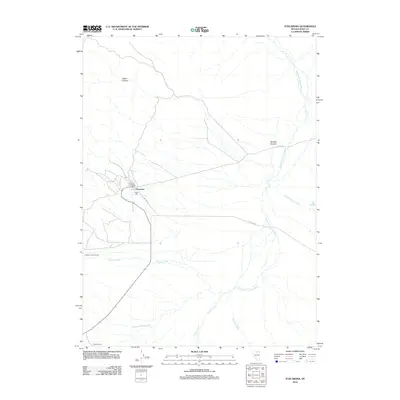
2012 Map of Tuscarora
USGS Topo · Published 2012About this map
Tuscarora stands as a focal point of this high-desert landscape in Elko County, serving as a reminder of Nevada's silver mining legacy. The map details the specific infrastructure supporting this community, including the Tuscarora Post Office and the Dexter Mill, which sits just outside the main settlement area. The surrounding terrain is defined by its water sources and ranching history, with the South Fork Owyhee River and Taylors Cañon Creek flowing through the eastern reaches. Local ranching operations like the Quarter Circle S Ranch and Packer Ranch are clearly identified, illustrating the transition from 19th-century mining fever to more enduring agricultural pursuits. The network of canyons, such as Arthur Canyon and Sixmile Canyon, alongside the path of Airport RD, highlights how the geography influenced modern access to this remote region.
Find a feature on this map
16 named features on this map. Tap any name to fly to it.
Don’t see what you’re looking for? This feature index may not catch every label — zoom into the map to look around manually.
Map Details
Editions of this 2012 Tuscarora Map
This is the sole edition of this map. No revisions or reprints were ever made.
Other maps of this area

1955 · McDermitt
USGS Topo · 1:250,000

1956 · Tuscarora
USGS Topo · 1:62,500

1956 · Mt. Blitzen
USGS Topo · 1:62,500

1959 · McDermitt
USGS Topo · 1:250,000

1970 · Sugarloaf Butte
USGS Topo · 1:24,000

1970 · Lake Mountain
USGS Topo · 1:24,000

1970 · Stampede Ranch
USGS Topo · 1:24,000
1972 · Lake Mountain
USGS Topo · 1:24,000

1982 · Tuscarora
USGS Topo · 1:100,000
1987 · Cottonwood Peak
USGS Topo · 1:24,000