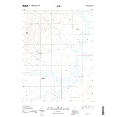
2018 Map of Tuscarora
USGS Topo · Published 2018About this map
Tuscarora sits at the intersection of high desert terrain and drainage networks in Elko County, marking a persistent human footprint in the Great Basin. To the west, the Tuscarora Mountains rise toward Mt Blitzen, while the eastern portion of the landscape opens into the expansive Independence Valley. This 2018 survey reveals a network of remote roads, including Midas Rd and N Tuscarora Rd, which navigate the rugged topography and canyon systems like Arthur Canyon and Sixmile Canyon. Hydrologically, the area is defined by the S Fork Owyhee River and Crooked Cr, which provide vital drainage through the high-elevation flats. The settlement pattern remains concentrated around the original townsite, surrounded by a grid of townships including t40n r51e and t40n r52e, illustrating the enduring legacy of 19th-century land surveys in this cattle-and-mining region.
Find a feature on this map
15 named features on this map. Tap any name to fly to it.
Don’t see what you’re looking for? This feature index may not catch every label — zoom into the map to look around manually.
Map Details
Editions of this 2018 Tuscarora Map
This is the sole edition of this map. No revisions or reprints were ever made.
Other maps of this area

1955 · McDermitt
USGS Topo · 1:250,000

1956 · Tuscarora
USGS Topo · 1:62,500

1956 · Mt. Blitzen
USGS Topo · 1:62,500

1959 · McDermitt
USGS Topo · 1:250,000

1970 · Sugarloaf Butte
USGS Topo · 1:24,000

1970 · Lake Mountain
USGS Topo · 1:24,000

1970 · Stampede Ranch
USGS Topo · 1:24,000
1972 · Lake Mountain
USGS Topo · 1:24,000

1982 · Tuscarora
USGS Topo · 1:100,000
1987 · Cottonwood Peak
USGS Topo · 1:24,000