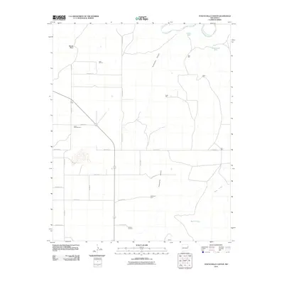
2010 Map of Tuscocoillo Canyon
USGS Topo · Published 2010About this map
Anniston Cemetery and several established family ranches define the high plains landscape of Quay County at the start of the 21st century. The map illustrates a region where water management is central to survival, marked by a network of specialized infrastructure such as Ealen Windmill and South Woods Windmill. Local settlement patterns are tied to geography and grazing, with named locations like Woods Place, Cox Ranch, and Molyneaux Ranch serving as primary landmarks across the grid of Quay roads. The rugged north is carved by the Canadian River and its namesake drainage, Tuscocoillo Canyon. This 2010 survey provides a look at the modern persistence of traditional New Mexico ranching culture, showing how life continues to revolve around vital water sources like Red Hill Tank, West Well, and Collins Tank.
Find a feature on this map
29 named features on this map. Tap any name to fly to it.
Don’t see what you’re looking for? This feature index may not catch every label — zoom into the map to look around manually.
Map Details
Editions of this 2010 Tuscocoillo Canyon Map
This is the sole edition of this map. No revisions or reprints were ever made.
Other maps of this area

1954 · Tucumcari
USGS Topo · 1:250,000

1958 · Tucumcari
USGS Topo · 1:250,000

1962 · Logan
USGS Topo · 1:62,500

1968 · Porter
USGS Topo · 1:24,000

1968 · Blue Hole
USGS Topo · 1:24,000

1968 · Bard
USGS Topo · 1:24,000

1968 · San Jon NW
USGS Topo · 1:24,000

1968 · Cammak Camp
USGS Topo · 1:24,000
1989 · Tuscocoillo Canyon
USGS Topo · 1:24,000
1989 · Logan South
USGS Topo · 1:24,000