
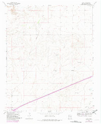
1968 Map of Bard
USGS Topo · Published 1971About this map
Bard serves as a central point of reference in this landscape of the New Mexico plains, where the C R I & P railroad tracks cut a diagonal path across the southern terrain. This late-1960s survey illustrates a region defined by its water management and transportation corridors, notably featuring the iconic Highway 66 running parallel to the rail line. The reliance on subterranean water in this arid environment is evident through a scattered network of named landmarks such as North Windmill, Salty Windmill, and Twin Windmills. To the southeast, the Endee Cem stands near the banks of Trujillo Creek, providing a significant touchstone for genealogists. The topography is further shaped by drainage patterns from Frost Creek and industrial activity at a local Gravel Pit, reflecting a rural economy tied to both the land and the transit routes heading toward the Texas border.
Find a feature on this map
17 named features on this map. Tap any name to fly to it.
Don’t see what you’re looking for? This feature index may not catch every label — zoom into the map to look around manually.
Map Details
Editions of this 1968 Bard Map
2 editions found
Other maps of this area

1954 · Tucumcari
USGS Topo · 1:250,000

1958 · Tucumcari
USGS Topo · 1:250,000

1962 · Logan
USGS Topo · 1:62,500

1968 · Porter
USGS Topo · 1:24,000

1968 · Rock Camp
USGS Topo · 1:24,000

1968 · Blue Hole
USGS Topo · 1:24,000

1968 · Riley Camp
USGS Topo · 1:24,000

1968 · San Jon
USGS Topo · 1:24,000

1968 · Glenrio
USGS Topo · 1:24,000
1968 · Martin Draw
USGS Topo · 1:24,000