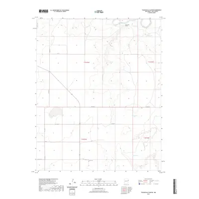
2020 Map of Tuscocoillo Canyon
USGS Topo · Published 2020About this map
Tuscocoillo Canyon winds through the high plains of Quay County, where the Canadian River cuts across the northern edge of the landscape. This 2020 survey documents a ranching environment defined by a grid of numbered roads, including Quay Road T and Quay Road 72, which navigate the elevation changes between the canyon floor and the surrounding plateaus. The placement of livestock watering sites like Collins Tank, Hard Bottom Tank, and Red Hill Tank highlights the essential water management required in this arid region of Eastern New Mexico. Genealogists and local historians will find the Anniston Cem in the southern portion of the map, a small but significant landmark of the area's rural settlement history. The map also delineates township and range boundaries such as t13n r34e and t12n r35e, reflecting the systematic public land survey structure that continues to define property and administration in the region.
Find a feature on this map
18 named features on this map. Tap any name to fly to it.
Don’t see what you’re looking for? This feature index may not catch every label — zoom into the map to look around manually.
Map Details
Editions of this 2020 Tuscocoillo Canyon Map
This is the sole edition of this map. No revisions or reprints were ever made.
Other maps of this area

1954 · Tucumcari
USGS Topo · 1:250,000

1958 · Tucumcari
USGS Topo · 1:250,000

1962 · Logan
USGS Topo · 1:62,500

1968 · Porter
USGS Topo · 1:24,000

1968 · Blue Hole
USGS Topo · 1:24,000

1968 · Bard
USGS Topo · 1:24,000

1968 · San Jon NW
USGS Topo · 1:24,000

1968 · Cammak Camp
USGS Topo · 1:24,000
1989 · Tuscocoillo Canyon
USGS Topo · 1:24,000
1989 · Logan South
USGS Topo · 1:24,000