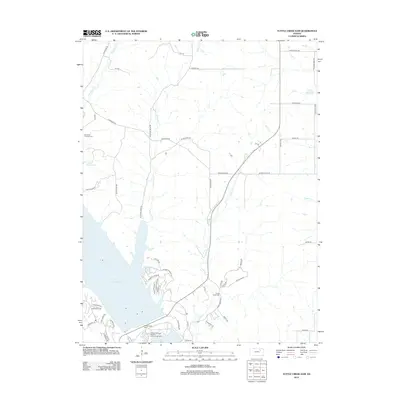
2012 Map of Tuttle Creek Dam
USGS Topo · Published 2012About this map
Tuttle Creek Dam anchors the southern end of the massive reservoir on the Big Blue River, creating a complex geography of engineered water management and preserved recreation areas in Riley County. The map details the Tuttle Creek State Park River Pond Campground and the adjacent River Pond below the dam, where modern access roads like Spillway Marina Rd and Pheasant Ridge Rd serve the lakeside community. North of the lake, the landscape transitions into a grid of rural roads and creek drainages including Carnahan Cr and McIntyre Cr. This 2012 survey captures the preservation of early local history amidst modern development, specifically through the location of the Carnahan - Garrison Cem and Cedar Creek Cem, which remain as markers of the area's original settlement patterns before the impoundment of Tuttle Creek Lake.
Find a feature on this map
48 named features on this map. Tap any name to fly to it.
Don’t see what you’re looking for? This feature index may not catch every label — zoom into the map to look around manually.
Map Details
Editions of this 2012 Tuttle Creek Dam Map
This is the sole edition of this map. No revisions or reprints were ever made.
Other maps of this area

1886 · Junction City
USGS Topo · 1:125,000

1889 · Wamego
USGS Topo · 1:125,000

1889 · Junction City
USGS Topo · 1:125,000

1894 · Junction City
USGS Topo · 1:125,000

1894 · Wamego
USGS Topo · 1:125,000

1947 · Manhattan
USGS Topo · 1:62,500

1950 · Keats
USGS Topo · 1:24,000

1950 · Manhattan
USGS Topo · 1:24,000

1953 · St George
USGS Topo · 1:24,000
1955 · Manhattan
USGS Topo · 1:24,000