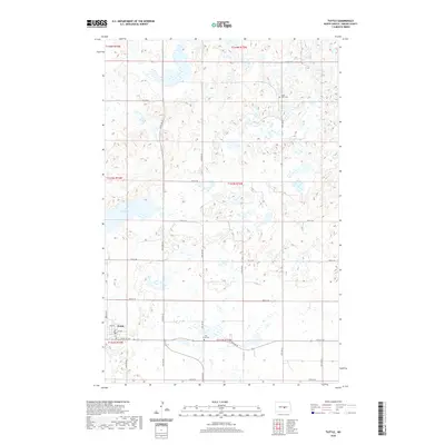
2020 Map of Tuttle
USGS Topo · Published 2020About this map
Tuttle serves as the primary settlement in this section of Kidder County, established along a grid of local roads like Main St and 1st Ave. The landscape is dominated by a dense network of prairie potholes and wetlands, most notably the expansive Lake Josephine to the northwest. This topography reflects the glacial history of the Missouri Coteau, where numerous small, unnamed water bodies create a complex drainage pattern across the township lines. The local social fabric of the era is anchored by sites of community and memory, including Saint Petri Cem in the northeast and Holy Cross Cem just east of the village. A central Post Office in town marks its role as a local hub for the surrounding rural sections. The map provides a detailed view of the section lines and township boundaries, including t143n r73w and t142n r74w, which define the cadastral layout of these North Dakota plains.
Find a feature on this map
29 named features on this map. Tap any name to fly to it.
Don’t see what you’re looking for? This feature index may not catch every label — zoom into the map to look around manually.
Map Details
Editions of this 2020 Tuttle Map
This is the sole edition of this map. No revisions or reprints were ever made.
Other maps of this area

1952 · New Rockford
USGS Topo · 1:250,000

1954 · McClusky
USGS Topo · 1:250,000

1956 · New Rockford
USGS Topo · 1:250,000

1958 · McClusky
USGS Topo · 1:250,000

1971 · New Rockford
USGS Topo · 1:250,000

1972 · Tuttle
USGS Topo · 1:24,000
1972 · Horsehead Lake
USGS Topo · 1:24,000

1972 · Robinson
USGS Topo · 1:24,000
1972 · Tuttle SW
USGS Topo · 1:24,000
1978 · Willow Lake
USGS Topo · 1:24,000