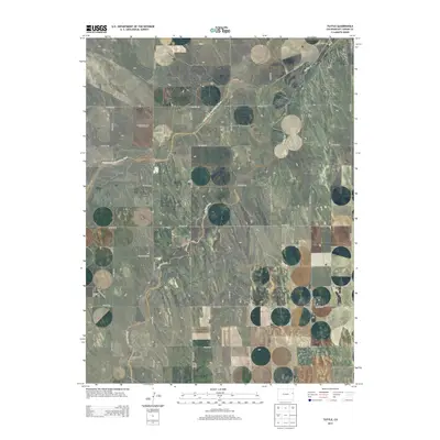
2013 Map of Tuttle
USGS Topo · Published 2013About this map
The South Fork Republican River carves a winding path across the high plains of Kit Carson County, defining the drainage patterns of this rural landscape. This modern survey illustrates the persistent agricultural and ranching grid that organizes the terrain, where a network of gravel routes like CO Road 31 and CO Road HH facilitate movement between sections. Tributaries such as Spring Creek and the intermittent Dry Gulch cut through the topographical contours, revealing the subtle elevation changes of the watershed. The area remains dominated by open land and water management, with the riverbed and its surrounding valleys serving as the primary geographic focal points for local land use and hydrology.
Find a feature on this map
27 named features on this map. Tap any name to fly to it.
Don’t see what you’re looking for? This feature index may not catch every label — zoom into the map to look around manually.
Map Details
Editions of this 2013 Tuttle Map
This is the sole edition of this map. No revisions or reprints were ever made.
Other maps of this area

1954 · Limon
USGS Topo · 1:250,000

1957 · Limon
USGS Topo · 1:250,000

1958 · Limon
USGS Topo · 1:250,000
1969 · Settlement
USGS Topo · 1:24,000
1969 · Tuttle
USGS Topo · 1:24,000
1969 · Bethune
USGS Topo · 1:24,000
1969 · Idalia SW
USGS Topo · 1:24,000
1969 · Kirk
USGS Topo · 1:24,000
1969 · Stratton
USGS Topo · 1:24,000
1978 · Joes SW
USGS Topo · 1:24,000