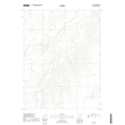
2019 Map of Tuttle
USGS Topo · Published 2019About this map
The South Fork Republican River winds through the northwestern corner of this Kit Carson County landscape, carving a wide valley floor through the high plains. This 2019 survey documents a vast grid of section lines and gravel routes, including Co RD 31 and Co RD HH, which define the agricultural divisions of the Eastern Plains. The terrain is marked by the branching drainages of Spring Creek and the smaller Spring Cr to the north, which channel runoff from the surrounding plateaus. In the southeastern portion of the quadrangle, Dry Gulch cuts deep into the land, reflecting the persistent erosion patterns typical of this semi-arid region. The map reflects a landscape dedicated to large-scale ranching and dryland farming, where water sources like the Republican River remain the primary geographical anchors.
Find a feature on this map
22 named features on this map. Tap any name to fly to it.
Don’t see what you’re looking for? This feature index may not catch every label — zoom into the map to look around manually.
Map Details
Editions of this 2019 Tuttle Map
This is the sole edition of this map. No revisions or reprints were ever made.
Other maps of this area

1954 · Limon
USGS Topo · 1:250,000

1957 · Limon
USGS Topo · 1:250,000

1958 · Limon
USGS Topo · 1:250,000
1969 · Settlement
USGS Topo · 1:24,000
1969 · Tuttle
USGS Topo · 1:24,000
1969 · Bethune
USGS Topo · 1:24,000
1969 · Idalia SW
USGS Topo · 1:24,000
1969 · Kirk
USGS Topo · 1:24,000
1969 · Stratton
USGS Topo · 1:24,000
1978 · Joes SW
USGS Topo · 1:24,000