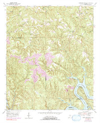
1949 Map of Tutwiler School
USGS Topo · Published 1991About this map
Tutwiler School and its surrounding community anchor this mid-century look at the ridge-and-valley landscape along the borders of Walker and Tuscaloosa counties. The terrain is defined by a dense network of watercourses including Indian Creek and White Oak Creek, which feed into the Black Warrior River and the expansive Bankhead Lake in the southeast. While local life centered around rural gathering points like Reynolds Sch and Cedar Creek Ch, the 1970s revisions to this map reveal the encroaching industrial footprint of a significant Strip Mine south of Three Forks. Family-named landmarks such as Thompson Mtn and Wallace Hill rise above the drainage basins, while the High Hill Fire Tower stands as a prominent lookout over the wooded hills of the Black Warrior basin during the post-war era.
Find a feature on this map
42 named features on this map. Tap any name to fly to it.
Don’t see what you’re looking for? This feature index may not catch every label — zoom into the map to look around manually.
Map Details
Editions of this 1949 Tutwiler School Map
3 editions found

Other maps of this area

1893 · Jasper
USGS Topo · 1:125,000

1899 · Brookwood
USGS Topo · 1:125,000

1927 · Adger
USGS Topo · 1:48,000

1929 · Searles
USGS Topo · 1:48,000

1932 · Yolande
USGS Topo · 1:62,500

1934 · Searles
USGS Topo · 1:62,500

1935 · Port Birmingham
USGS Topo · 1:48,000

1935 · Yolande
USGS Topo · 1:62,500

1938 · Port Birmingham
USGS Topo · 1:62,500

1949 · Parrish
USGS Topo · 1:24,000