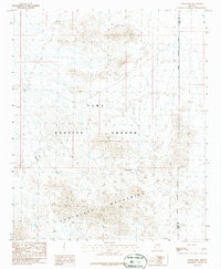
1986 Map of Tweed Mine
USGS Topo · Published 1986About this map
The Chocolate Mountains dominate this 1980s landscape, a region defined by its intersection of military operations and historical extraction. Most of the territory falls within the Yuma Proving Ground, where the Military Reservation Boundary delineates a vast expanse of desert terrain used for testing. For those tracing the history of desert mining, the map provides precise locations for the Tweed Mine, an isolated Mine Shaft, and numerous unnamed Prospect and Prospects sites. The drainage patterns of the Tyson Wash, Mohave Wash, and Gould Wash reveal the erosional forces shaping this arid corner of La Paz and Yuma counties. This provisional edition preserves the industrial and tactical geography of the area just as modern mapping technologies were beginning to refine these remote desert coordinates.
Find a feature on this map
12 named features on this map. Tap any name to fly to it.
Don’t see what you’re looking for? This feature index may not catch every label — zoom into the map to look around manually.
Map Details
Editions of this 1986 Tweed Mine Map
This is the sole edition of this map. No revisions or reprints were ever made.
Other maps of this area

1934 · Trigo Peaks
USGS Topo · 1:48,000

1939 · Red Hill
USGS Topo · 1:62,500

1939 · Trigo Peaks
USGS Topo · 1:62,500

1942 · Blythe
USGS Topo · 1:250,000

1954 · Salton Sea
USGS Topo · 1:250,000

1954 · Red Hill
USGS Topo · 1:62,500

1954 · Trigo Peaks
USGS Topo · 1:62,500

1955 · Salton Sea
USGS Topo · 1:250,000

1959 · Salton Sea
USGS Topo · 1:250,000
1962 · Livingston Hills
USGS Topo · 1:62,500