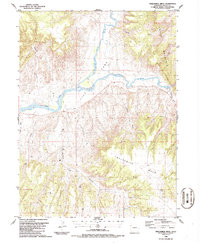
1986 Map of Twelvemile Mesa
USGS Topo · Published 1986About this map
The confluence of the Little Snake River and the Yampa River anchors this mid-1980s look at the Moffat County landscape. The rivers wind through the broad valley of Lily Park, a significant break in the surrounding topography where water and irrigation from a Ditch system supported local agriculture. To the east, the terrain rises sharply into the high ridges of Cross Mountain, while the southern half of the quadrangle is dominated by the sprawling plateau of Twelvemile Mesa. Evidence of human activity and resource exploration is scattered throughout the region, from a lonely Grave in the river valley to a Radio Tower and a Drill Hole in the higher elevations. Recreation sites such as Roadside Park and a Picnic Area highlight the area's use as a transit corridor between the deep canyons and the open tablelands.
Find a feature on this map
19 named features on this map. Tap any name to fly to it.
Don’t see what you’re looking for? This feature index may not catch every label — zoom into the map to look around manually.
Map Details
Editions of this 1986 Twelvemile Mesa Map
This is the sole edition of this map. No revisions or reprints were ever made.
Other maps of this area

1907 · Rangely
USGS Topo · 1:125,000

1907 · White River
USGS Topo · 1:125,000

1910 · White River
USGS Topo · 1:125,000

1910 · Rangely
USGS Topo · 1:125,000

1954 · Vernal
USGS Topo · 1:250,000

1958 · Vernal
USGS Topo · 1:250,000

1960 · Vernal
USGS Topo · 1:250,000

1960 · Elk Springs
USGS Topo · 1:62,500

1960 · Lone Mountain
USGS Topo · 1:62,500
1962 · M F Mountain
USGS Topo · 1:24,000