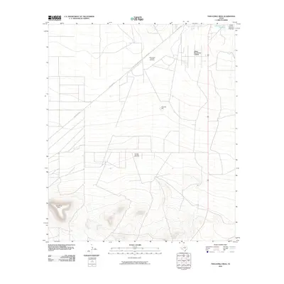
2010 Map of Twelvemile Mesa
USGS Topo · Published 2010About this map
The Leon Valley Oil and Gas Field and Belding Oil and Gas Field dominate the mid-section of this landscape, illustrating the industrial footprint of energy extraction in Pecos County. The terrain transitions from the low-lying reaches near Comanche Creek Reservoir and the adjacent East Hill Cemetery toward the prominent elevations of Twelvemile Mesa in the southwest and Fivemile Hill to the east. Transportation through this part of the Trans-Pecos is anchored by the diagonal path of the Old Alpine Hwy. The settlement of Alamo Ranchettes Colonia stands as a primary residential cluster in an otherwise arid expanse defined by complex contour lines and localized water management features like the Comanche Creek Dam.
Find a feature on this map
9 named features on this map. Tap any name to fly to it.
Don’t see what you’re looking for? This feature index may not catch every label — zoom into the map to look around manually.
Map Details
Editions of this 2010 Twelvemile Mesa Map
This is the sole edition of this map. No revisions or reprints were ever made.
Other maps of this area

1921 · Fort Stockton
USGS Topo · 1:62,500

1923 · Fort Stockton
USGS Topo · 1:62,500

1923 · Sierra Madera
USGS Topo · 1:62,500

1928 · Comanche Spring
USGS Topo · 1:125,000

1929 · Hovey
USGS Topo · 1:125,000

1954 · Fort Stockton
USGS Topo · 1:250,000

1958 · Fort Stockton
USGS Topo · 1:250,000

1970 · Fort Stockton West
USGS Topo · 1:24,000

1970 · Twelvemile Mesa
USGS Topo · 1:24,000
1970 · Fivemile Mesa
USGS Topo · 1:24,000