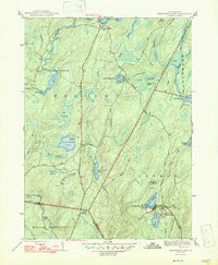
1947 Map of Twelvemile Pond
USGS Topo · Published 1947About this map
Pike County's high wetlands and sporting clubs define this 1940s landscape, where private preserves like Porters Lake Club and Beaver Run Club occupied large tracts of the Porter and Lehman townships. The topography is dominated by an intricate network of glacial basins and drainage, including Twelvemile Pond, Lake Minisink, and the expansive Inlet Swamp. This era shows a transition from local rural life—anchored by the Hunters Range Sch—to the establishment of vacation and recreation sites such as Camp Taminiment and Forest Park. Evidence of earlier travel routes persists in labels like Old Shohola Road, while infrastructure developments like the Beaver Run Dam reflect mid-century water management efforts across the Bushkill Creek watershed. The map illustrates a region shifting from remote timberland and small settlements like Sandyville toward a formalized recreational corridor.
Find a feature on this map
47 named features on this map. Tap any name to fly to it.
Don’t see what you’re looking for? This feature index may not catch every label — zoom into the map to look around manually.
Map Details
Editions of this 1947 Twelvemile Pond Map
2 editions found
Other maps of this area

1891 · Wallpack
USGS Topo · 1:62,500

1893 · Wallpack
USGS Topo · 1:62,500

1913 · Milford
USGS Topo · 1:62,500

1915 · Milford
USGS Topo · 1:62,500

1924 · Bushkill
USGS Topo · 1:48,000

1935 · Hawley
USGS Topo · 1:62,500

1938 · Hawley
USGS Topo · 1:62,500

1943 · Bushkill
USGS Topo · 1:62,500

1943 · Lake Maskenozha
USGS Topo · 1:31,680
1943 · Flatbrookville
USGS Topo · 1:31,680
Featured Places
- Lehman Township, PA
- Delaware Township, PA
- Porter Township, PA
- Middle Smithfield Township, PA
- Pine Flats, Porter Township