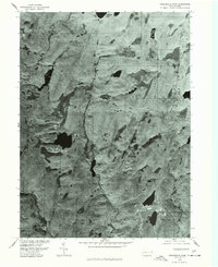
1976 Map of Twelvemile Pond
USGS Topo · Published 1978About this map
Sandyville and the surrounding wilderness of Pike County appear in high detail on this orthophotograph, which was prepared from aerial imagery captured in late 1976. This specific type of survey combines the visual accuracy of a photograph with the geometric precision of a topographic map, revealing the dense forest cover and complex wetlands characteristic of the Pocono region. In the southern portion of the sheet, the residential layout of Forest Park is visible, while the northern reaches are dominated by significant water bodies and marshlands. The landscape is defined by the dark, still waters of Twelvemile Pond and Porters Lake, nestled among topographic landmarks like Pine Flats and the expanse of Nebo Swamp. This map provides a clear look at the area's rural development and natural drainage patterns just before the late-century growth of the region.
Find a feature on this map
6 named features on this map. Tap any name to fly to it.
Don’t see what you’re looking for? This feature index may not catch every label — zoom into the map to look around manually.
Map Details
Editions of this 1976 Twelvemile Pond Map
This is the sole edition of this map. No revisions or reprints were ever made.
Other maps of this area

1891 · Wallpack
USGS Topo · 1:62,500

1893 · Wallpack
USGS Topo · 1:62,500

1913 · Milford
USGS Topo · 1:62,500

1915 · Milford
USGS Topo · 1:62,500

1924 · Bushkill
USGS Topo · 1:48,000

1935 · Hawley
USGS Topo · 1:62,500

1938 · Hawley
USGS Topo · 1:62,500

1943 · Bushkill
USGS Topo · 1:62,500

1943 · Lake Maskenozha
USGS Topo · 1:31,680
1943 · Flatbrookville
USGS Topo · 1:31,680
Featured Places
- Lehman Township, PA
- Delaware Township, PA
- Porter Township, PA
- Middle Smithfield Township, PA
- Pine Flats, Porter Township