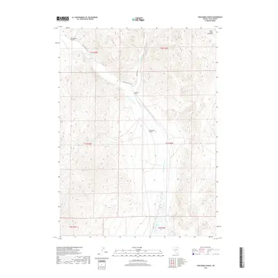
2018 Map of Twelvemile Ranch
USGS Topo · Published 2018About this map
Twelvemile Ranch serves as the central landmark in this high-desert pocket of Elko County, where the high drainage systems of Thousand Springs Cr and Crittenden Cr converge. The landscape is defined by the transition from the foothills of the Goose Creek Mountains in the northeast to the broad alluvial basins below. Transportation is limited to rugged corridors like Wilkins-Montello Rd, reflecting a sparse ranching economy dependent on reliable water sources such as Red Hot Spring.
Find a feature on this map
15 named features on this map. Tap any name to fly to it.
Don’t see what you’re looking for? This feature index may not catch every label — zoom into the map to look around manually.
Map Details
Editions of this 2018 Twelvemile Ranch Map
This is the sole edition of this map. No revisions or reprints were ever made.
Other maps of this area

1955 · Wells
USGS Topo · 1:250,000

1958 · Wells
USGS Topo · 1:250,000

1961 · Wells
USGS Topo · 1:250,000
1961 · Delano Mountains
USGS Topo · 1:62,500
1961 · Dairy Valley
USGS Topo · 1:62,500
1967 · Jackson Spring
USGS Topo · 1:24,000
1967 · Montello Canyon
USGS Topo · 1:24,000
1967 · Twelvemile Ranch
USGS Topo · 1:24,000
1967 · Montello
USGS Topo · 1:24,000
1967 · Ninemile Mtn NE
USGS Topo · 1:24,000