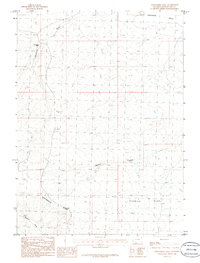
1986 Map of Twelvemile Well
USGS Topo · Published 1986About this map
The Continental Divide winds through the southwestern portion of this Sweetwater County landscape, defining the high drainage boundaries of this arid Wyoming terrain. The 1980s data illustrates a sparse, functional environment where water access is the primary marker of human presence and survival. Features like the Twelvemile Well stand as vital landmarks for those traversing the high desert, providing a specific point of reference in an area otherwise characterized by broad basins and dry watercourses. Ephemeral drainage patterns are clearly mapped, including the meandering paths of Twelvemile Gulch, Dugout Draw, and Tenmile Draw. To the southeast, the terrain opens into the expansive Tenmile Flat, showing the relationship between the elevated divide and the lower catchment areas that define the region's topography.
Find a feature on this map
8 named features on this map. Tap any name to fly to it.
Don’t see what you’re looking for? This feature index may not catch every label — zoom into the map to look around manually.
Map Details
Editions of this 1986 Twelvemile Well Map
This is the sole edition of this map. No revisions or reprints were ever made.
Other maps of this area

1954 · Rock Springs
USGS Topo · 1:250,000

1958 · Rock Springs
USGS Topo · 1:250,000

1958 · Twelvemile Well
USGS Topo · 1:62,500

1960 · Red Lake
USGS Topo · 1:62,500

1962 · Rock Springs
USGS Topo · 1:250,000

1968 · Bitter Creek NW
USGS Topo · 1:24,000

1968 · Bitter Creek NE
USGS Topo · 1:24,000
1970 · Desert Springs
USGS Topo · 1:24,000
1980 · Red Desert Basin
USGS Topo · 1:100,000
1986 · Black Rock Flat East
USGS Topo · 1:24,000