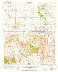
1955 Map of Twentynine Palms
USGS Topo · Published 1961About this map
Joshua Tree National Monument dominates the southern landscape of this mid-century survey, revealing a high-desert environment defined by the transition between the Pinto Mountains and the Little San Bernardino Mountains. The township of Twentynine Palms is shown in a period of establishment, clustered around the Oasis of Mara and The Plaza. To the north, the Marine Corps Training Center occupies the area around Mesquite Lake, while the iconic Wonderland of Rocks and Queen Mountain anchor the central wilderness. Local landmarks such as Barker Dam and the Desert Queen Mine provide tangible evidence of early ranching and mining efforts in this arid terrain. The map also delineates the Twentynine Palms Indian Res and early transport routes like the Amboy Road and Twentynine Palms Highway.
Find a feature on this map
47 named features on this map. Tap any name to fly to it.
Don’t see what you’re looking for? This feature index may not catch every label — zoom into the map to look around manually.
Map Details
Editions of this 1955 Twentynine Palms Map
5 editions found

Other maps of this area

1941 · Edom
USGS Topo · 1:62,500

1942 · Amboy
USGS Topo · 1:250,000

1943 · Amboy
USGS Topo · 1:250,000

1943 · Pinkham Well
USGS Topo · 1:62,500

1944 · Pinkham Well
USGS Topo · 1:62,500

1944 · Edom
USGS Topo · 1:62,500

1944 · Pinyon Well
USGS Topo · 1:62,500

1947 · Santa Ana
USGS Topo · 1:250,000

1949 · Santa Ana
USGS Topo · 1:250,000

1953 · San Bernardino
USGS Topo · 1:250,000
Featured Places
- Twentynine Palms, CA
- Desert Heights, CA
- Sunfair Heights, CA
- Panorama Heights, CA
- Smoke Tree, Twentynine Palms