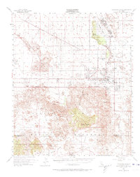
1955 Map of Twentynine Palms
USGS Topo · Published 1973About this map
The Oasis of Mara serves as a historic focal point for this high-desert region, situated near the Twentynine Palms Indian Res and the established town of Twentynine Palms. The landscape transitions from the urbanized grid of The Plaza and Four Corners to the protected expanse of Joshua Tree National Monument. Within this southern portion of the map, complex geological features like the Wonderland of Rocks and Rattlesnake Canyon dominate the terrain, while reliable water sources such as Willow Hole and Fortynine Palms Oasis provide critical relief in an arid environment.
Find a feature on this map
55 named features on this map. Tap any name to fly to it.
Don’t see what you’re looking for? This feature index may not catch every label — zoom into the map to look around manually.
Map Details
Editions of this 1955 Twentynine Palms Map
5 editions found

Other maps of this area

1941 · Edom
USGS Topo · 1:62,500

1942 · Amboy
USGS Topo · 1:250,000

1943 · Amboy
USGS Topo · 1:250,000

1943 · Pinkham Well
USGS Topo · 1:62,500

1944 · Pinkham Well
USGS Topo · 1:62,500

1944 · Edom
USGS Topo · 1:62,500

1944 · Pinyon Well
USGS Topo · 1:62,500

1947 · Santa Ana
USGS Topo · 1:250,000

1949 · Santa Ana
USGS Topo · 1:250,000

1953 · San Bernardino
USGS Topo · 1:250,000
Featured Places
- Twentynine Palms, CA
- Desert Heights, CA
- Sunfair Heights, CA
- Panorama Heights, CA
- Smoke Tree, Twentynine Palms