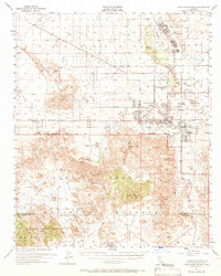
1955 Map of Twentynine Palms
USGS Topo · Published 1966About this map
Twentynine Palms and its surrounding desert landscapes are documented here during the mid-1950s, showing a transition from a small desert outpost to a region defined by federal activity. The village center, focused around The Plaza and Four Corners, sits north of the Oasis of Mara and the Twentynine Palms Indian Res. To the north, the massive Marine Corps Training Center occupies the basin near Mesquite Lake, while the southern reaches of the map climb into the high-elevation terrain of the Little San Bernardino Mountains. This survey provides a detailed look at early road networks like Amboy Road and Adobe Road before significant modern expansion. Cultural markers such as the Desert Queen Mine and Barker Dam indicate the area's history of mineral extraction and water management in a landscape featuring the Wonderland of Rocks and Fortynine Palms Oasis.
Find a feature on this map
53 named features on this map. Tap any name to fly to it.
Don’t see what you’re looking for? This feature index may not catch every label — zoom into the map to look around manually.
Map Details
Editions of this 1955 Twentynine Palms Map
5 editions found

Other maps of this area

1941 · Edom
USGS Topo · 1:62,500

1942 · Amboy
USGS Topo · 1:250,000

1943 · Amboy
USGS Topo · 1:250,000

1943 · Pinkham Well
USGS Topo · 1:62,500

1944 · Pinkham Well
USGS Topo · 1:62,500

1944 · Edom
USGS Topo · 1:62,500

1944 · Pinyon Well
USGS Topo · 1:62,500

1947 · Santa Ana
USGS Topo · 1:250,000

1949 · Santa Ana
USGS Topo · 1:250,000

1953 · San Bernardino
USGS Topo · 1:250,000
Featured Places
- Twentynine Palms, CA
- Desert Heights, CA
- Sunfair Heights, CA
- Panorama Heights, CA
- Smoke Tree, Twentynine Palms