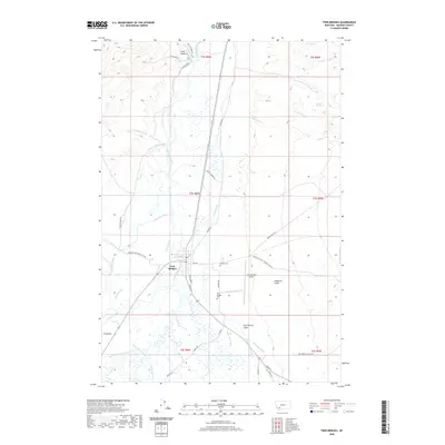
2020 Map of Twin Bridges
USGS Topo · Published 2020About this map
Twin Bridges serves as the focal point of this Madison County landscape, situated at the significant confluence where the Big Hole River, Beaverhead River, and Ruby River unite to form the Jefferson River. The topography is defined by this intricate hydrography, featuring numerous irrigation and drainage channels such as Cornforth Ditch, Seyler-Tash Ditch, and Jacob Slough that support the local ranching economy. To the east, the terrain rises into Goodrich Gulch and Dry Georgia Gulch, while the valley floor is dotted with family-named landmarks and infrastructure including Bayers Ranch Rd and the Twin Bridges Airport. Local history is anchored by the Masonic Cem and Twin Bridges Cem, which provide essential touchpoints for genealogical research. The mapping of Hells Canyon and Bain Springs in the northern sections further illustrates the transition from the fertile river basin to the more arid upland country.
Find a feature on this map
53 named features on this map. Tap any name to fly to it.
Don’t see what you’re looking for? This feature index may not catch every label — zoom into the map to look around manually.
Map Details
Editions of this 2020 Twin Bridges Map
This is the sole edition of this map. No revisions or reprints were ever made.
Other maps of this area

1893 · Dillon
USGS Topo · 1:250,000

1955 · Dillon
USGS Topo · 1:250,000

1957 · Dillon
USGS Topo · 1:250,000

1958 · Dillon
USGS Topo · 1:250,000

1960 · Twin Bridges
USGS Topo · 1:62,500

1960 · Waterloo
USGS Topo · 1:62,500

1962 · Dillon
USGS Topo · 1:250,000
1962 · Beaverhead Rock
USGS Topo · 1:24,000
1962 · Beaverhead Rock NE
USGS Topo · 1:24,000
1963 · Sheridan
USGS Topo · 1:24,000