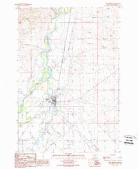
1989 Map of Twin Bridges
USGS Topo · Published 1989About this map
The confluence of the Big Hole River and the Beaverhead River creates the headwaters of the Jefferson River at the heart of this late-twentieth-century survey. The settlement of Twin Bridges is positioned strategically among these waterways, surrounded by a complex network of braids and backwaters including Owsley Slough, Third Slough, and Schoolhouse Slough. This riparian landscape is defined by its hydrologic activity, where the Ruby River also joins the system near the smaller locale of Jacobs.
Find a feature on this map
30 named features on this map. Tap any name to fly to it.
Don’t see what you’re looking for? This feature index may not catch every label — zoom into the map to look around manually.
Map Details
Editions of this 1989 Twin Bridges Map
This is the sole edition of this map. No revisions or reprints were ever made.
Other maps of this area

1893 · Dillon
USGS Topo · 1:250,000

1955 · Dillon
USGS Topo · 1:250,000

1957 · Dillon
USGS Topo · 1:250,000

1958 · Dillon
USGS Topo · 1:250,000

1960 · Twin Bridges
USGS Topo · 1:62,500

1960 · Waterloo
USGS Topo · 1:62,500

1962 · Dillon
USGS Topo · 1:250,000
1962 · Beaverhead Rock
USGS Topo · 1:24,000
1962 · Beaverhead Rock NE
USGS Topo · 1:24,000
1963 · Sheridan
USGS Topo · 1:24,000