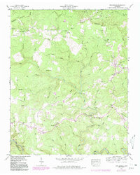
1943 Map of Twin Bridges
USGS Topo · Published 1980About this map
Deer Lodge Academy and the surrounding plateau terrain of the Tennessee Valley are captured here during a period of transition, with original 1943 field data supplemented by 1976 aerial revisions. The landscape is defined by the winding course of White Creek and its many tributaries, including Little Creek and Cook Creek. These waterways were central to local life, evidenced by named crossings like Lavender Bridge, Norris Ford, and White Ford.
Find a feature on this map
67 named features on this map. Tap any name to fly to it.
Don’t see what you’re looking for? This feature index may not catch every label — zoom into the map to look around manually.
Map Details
Editions of this 1943 Twin Bridges Map
4 editions found
Other maps of this area

1895 · Wartburg
USGS Topo · 1:125,000

1896 · Wartburg
USGS Topo · 1:125,000

1935 · Lancing
USGS Topo · 1:24,000

1935 · Pilot Mountain
USGS Topo · 1:24,000

1936 · Hebbertsburg
USGS Topo · 1:24,000

1936 · Fox Creek
USGS Topo · 1:24,000

1936 · Twin Bridges
USGS Topo · 1:24,000

1936 · Jones Knob
USGS Topo · 1:24,000
1943 · Hebbertsburg
USGS Topo · 1:24,000

1943 · Twin Bridges
USGS Topo · 1:24,000