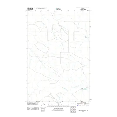
2011 Map of Twin Buttes School
USGS Topo · Published 2011About this map
Crow Rock Creek and its many seasonal tributaries define this section of eastern Montana, where the drainage network shapes the sparsely populated ranching landscape. The area is characterized by intermittent water sources and small-scale water management projects, such as the Hamlick Reservoir Dam and Kountz Dam. These features illustrate the vital role of water storage in a region dominated by the Hamlick Reservoir and the forks of Bachelor Creek. The layout of local roads and property boundaries follows the natural contours of the land, providing a view of the rural infrastructure at the beginning of the 21st century. The map also records the winding paths of Hay Creek and Finley Creek, showing how these waterways weave through the terrain before meeting larger drainage systems like Muster Creek.
Find a feature on this map
9 named features on this map. Tap any name to fly to it.
Don’t see what you’re looking for? This feature index may not catch every label — zoom into the map to look around manually.
Map Details
Editions of this 2011 Twin Buttes School Map
This is the sole edition of this map. No revisions or reprints were ever made.
Other maps of this area

1953 · Miles City
USGS Topo · 1:250,000

1954 · Forsyth
USGS Topo · 1:250,000

1957 · Miles City
USGS Topo · 1:250,000

1957 · Forsyth
USGS Topo · 1:250,000

1958 · Miles City
USGS Topo · 1:250,000

1958 · Forsyth
USGS Topo · 1:250,000

1965 · Little Sheep Mountain
USGS Topo · 1:24,000

1965 · Twin Buttes School
USGS Topo · 1:24,000
1965 · Combs Ranch
USGS Topo · 1:24,000
1965 · Crow Rock
USGS Topo · 1:24,000