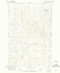
1965 Map of Crow Rock
USGS Topo · Published 1968About this map
Garfield and Prairie County borders bisect this mid-1960s landscape, where the small settlement of Crow Rock sits at the junction of several drainage systems. The terrain is defined by a dense network of intermittent watercourses including Ash Creek, Whites Creek, and Hay Creek, which carve into the high plains. A significant landmark in the northeast is Dinosaur Dam, featuring a Spillway that marks a rare point of managed water in this arid environment. Surveyed through photogrammetric methods in 1964 and field checked in 1965, the map captures a rural ranching era where fine red dashed lines indicate the placement of extensive fence lines across the open range. Occasional Well sites and remote landmarks like Crow Rock Creek and Wolf Creek provide essential orientation in a region shaped by isolated homesteads and livestock management.
Find a feature on this map
11 named features on this map. Tap any name to fly to it.
Don’t see what you’re looking for? This feature index may not catch every label — zoom into the map to look around manually.
Map Details
Editions of this 1965 Crow Rock Map
This is the sole edition of this map. No revisions or reprints were ever made.
Other maps of this area

1953 · Miles City
USGS Topo · 1:250,000

1954 · Jordan
USGS Topo · 1:250,000

1954 · Forsyth
USGS Topo · 1:250,000

1954 · Glendive
USGS Topo · 1:250,000

1956 · Jordan
USGS Topo · 1:250,000

1957 · Miles City
USGS Topo · 1:250,000

1957 · Glendive
USGS Topo · 1:250,000

1957 · Forsyth
USGS Topo · 1:250,000

1958 · Miles City
USGS Topo · 1:250,000

1958 · Jordan
USGS Topo · 1:250,000