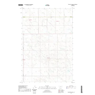
2020 Map of Twin Buttes School
USGS Topo · Published 2020About this map
Twin Buttes School stands as a focal point in this remote corner of Eastern Montana, situated near the jurisdictional boundary of Prairie Co and Custer Co. The landscape is defined by an intricate network of intermittent drainages, including Crow Rock Cr, Hay Cr, and Finley Cr, which carve through the high plains. The presence of Hamlick Reservoir in the southeastern quadrant suggests the importance of water management in this arid grazing country. Transportation is limited to rugged tracks like Rd 102 and Deadman Rd, which navigate the terrain between the headwaters of N Fork Bachelor Cr and S Fork Bachelor Cr. This survey illustrates the sparse, ranch-oriented settlement pattern typical of the region, where a single schoolhouse serves a vast geographic township.
Find a feature on this map
16 named features on this map. Tap any name to fly to it.
Don’t see what you’re looking for? This feature index may not catch every label — zoom into the map to look around manually.
Map Details
Editions of this 2020 Twin Buttes School Map
This is the sole edition of this map. No revisions or reprints were ever made.
Other maps of this area

1953 · Miles City
USGS Topo · 1:250,000

1954 · Forsyth
USGS Topo · 1:250,000

1957 · Miles City
USGS Topo · 1:250,000

1957 · Forsyth
USGS Topo · 1:250,000

1958 · Miles City
USGS Topo · 1:250,000

1958 · Forsyth
USGS Topo · 1:250,000

1965 · Little Sheep Mountain
USGS Topo · 1:24,000

1965 · Twin Buttes School
USGS Topo · 1:24,000
1965 · Combs Ranch
USGS Topo · 1:24,000
1965 · Crow Rock
USGS Topo · 1:24,000