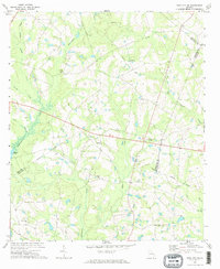
1971 Map of Twin City SE
USGS Topo · Published 1973About this map
Fifteenmile Creek and Cypress Creek define the hydrology of this rural landscape in the early 1970s, where several Georgia counties meet. The map reveals a community-focused geography centered on scattered country churches such as St Pauls Ch, Parris Grove Ch, and New Beulah Ch. These landmarks, often accompanied by local cemeteries, offer significant value for genealogists tracing family ties in the region. Transportation history is marked by the presence of an Old Railroad Grade cutting across the northern reaches of the quadrangle, illustrating the transition from rail-dependent industry to a road-based agricultural economy. In the west, Watson Pond provides a distinct water feature amidst a network of small branches and creeks including Nathan Creek and Sams Creek, showing the varied drainage patterns of the eastern Georgia terrain.
Find a feature on this map
22 named features on this map. Tap any name to fly to it.
Don’t see what you’re looking for? This feature index may not catch every label — zoom into the map to look around manually.
Map Details
Editions of this 1971 Twin City SE Map
2 editions found
Other maps of this area

1920 · Statesboro
USGS Topo · 1:62,500

1921 · Rocky Ford
USGS Topo · 1:62,500

1943 · Rocky Ford
USGS Topo · 1:62,500

1943 · Millen
USGS Topo · 1:125,000

1943 · Statesboro
USGS Topo · 1:62,500

1947 · Savannah
USGS Topo · 1:250,000

1948 · Savannah
USGS Topo · 1:250,000

1957 · Macon
USGS Topo · 1:250,000

1957 · Savannah
USGS Topo · 1:250,000

1958 · Macon
USGS Topo · 1:250,000