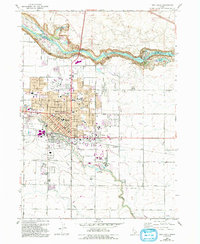
1964 Map of Twin Falls
USGS Topo · Published 1993About this map
The Snake River carves a dramatic northern boundary for Twin Falls, creating a landscape defined by steep canyon walls and significant water features. This edition shows the city's mid-century footprint alongside several 1980s updates, including the development of the Magic Valley Mall and the expansion of the College of Southern Idaho. The canyon itself is a focal point for recreation and industry, featuring the iconic Perrine Memorial Bridge, Shoshone Falls Park, and the Blue Lakes Country Club.
Find a feature on this map
61 named features on this map. Tap any name to fly to it.
Don’t see what you’re looking for? This feature index may not catch every label — zoom into the map to look around manually.
Map Details
Editions of this 1964 Twin Falls Map
2 editions found
Other maps of this area

1950 · Filer
USGS Topo · 1:24,000

1950 · Jerome
USGS Topo · 1:24,000

1950 · Jerome
USGS Topo · 1:62,500

1955 · Twin Falls
USGS Topo · 1:250,000

1958 · Twin Falls
USGS Topo · 1:250,000

1964 · Kimberly
USGS Topo · 1:24,000

1964 · Falls City
USGS Topo · 1:24,000

1964 · Twin Falls
USGS Topo · 1:24,000

1964 · Perrine
USGS Topo · 1:24,000

1965 · Stricker Butte
USGS Topo · 1:24,000