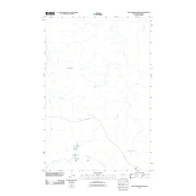
2011 Map of Twin Forks Reservoir
USGS Topo · Published 2011About this map
Twin Forks Reservoir and a series of managed water systems define this portion of Dawson County, Montana. The landscape is characterized by a network of drainage and storage, where Frank Creek and Magpie Creek cut through the terrain below Blue Mountain. The infrastructure of the area relies on a collection of smaller earthen works, including Twin Forks Dam, Lobella Dam, and Dwarf Dam, which regulate the flow into Upper Labelle Reservoir and the Labelle Ditch. This reliance on localized water management is further evidenced by Gagena Reservoir and the Lost Coulee Dam at the southern edge. The only primary overland route shown is Sandcreek Rd, which traverses the center of this sparse, ranch-oriented territory.
Find a feature on this map
13 named features on this map. Tap any name to fly to it.
Don’t see what you’re looking for? This feature index may not catch every label — zoom into the map to look around manually.
Map Details
Editions of this 2011 Twin Forks Reservoir Map
This is the sole edition of this map. No revisions or reprints were ever made.
Other maps of this area

1909 · Glendive
USGS Topo · 1:250,000

1953 · Miles City
USGS Topo · 1:250,000

1954 · Glendive
USGS Topo · 1:250,000

1957 · Miles City
USGS Topo · 1:250,000

1957 · Glendive
USGS Topo · 1:250,000

1958 · Miles City
USGS Topo · 1:250,000

1958 · Glendive
USGS Topo · 1:250,000

1967 · Allard
USGS Topo · 1:24,000
1967 · Glendive
USGS Topo · 1:24,000
1967 · Upper Magpie Reservoir
USGS Topo · 1:24,000