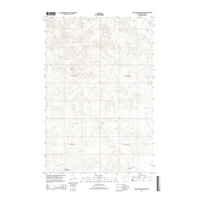
2014 Map of Twin Forks Reservoir
USGS Topo · Published 2014About this map
Twin Forks Reservoir and Gagena Reservoir sit at the heart of this Dawson County landscape, illustrating the critical role of water management in the high plains. The topography is defined by significant elevations like Blue Mtn and Rattlesnake Butte, which rise above a network of drainages including Frank Cr and Magpie Cr. This 2014 survey captures the persistence of agricultural infrastructure in eastern Montana, most notably through the Labelle Ditch, which traverses the southern portion of the quadrangle near Kelly Draw. The land is neatly partitioned by the Public Land Survey System into townships like t14n r56e, and movement through the area is facilitated by simple thoroughfares such as Road 114 and Road 118, reflecting a sparse, rural settlement pattern.
Find a feature on this map
15 named features on this map. Tap any name to fly to it.
Don’t see what you’re looking for? This feature index may not catch every label — zoom into the map to look around manually.
Map Details
Editions of this 2014 Twin Forks Reservoir Map
This is the sole edition of this map. No revisions or reprints were ever made.
Other maps of this area

1909 · Glendive
USGS Topo · 1:250,000

1953 · Miles City
USGS Topo · 1:250,000

1954 · Glendive
USGS Topo · 1:250,000

1957 · Miles City
USGS Topo · 1:250,000

1957 · Glendive
USGS Topo · 1:250,000

1958 · Miles City
USGS Topo · 1:250,000

1958 · Glendive
USGS Topo · 1:250,000
1967 · Allard
USGS Topo · 1:24,000
1967 · Glendive
USGS Topo · 1:24,000
1967 · Upper Magpie Reservoir
USGS Topo · 1:24,000