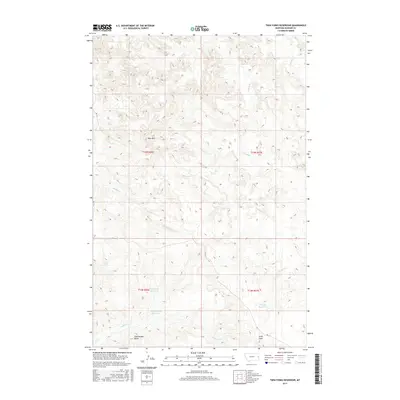
2017 Map of Twin Forks Reservoir
USGS Topo · Published 2017About this map
Twin Forks Reservoir and the surrounding high plains of Dawson County are defined here by a vital network of water management and ephemeral streams. The 2017 survey reveals an arid landscape where agricultural development relies on features like the Labelle Ditch, which feeds into the Upper Labelle Reservoir. These structures, alongside the Gugena Reservoir, indicate the importance of water catchment in eastern Montana’s ranching and farming economy. Prominent landforms such as Blue Mtn and Rattlesnake Butte provide significant vertical relief against the winding paths of Frank Cr and Magpie Cr. This map is particularly useful for understanding modern land division and water rights, showing how local topography like Kelly Draw dictates the placement of infrastructure and seasonal drainage.
Find a feature on this map
15 named features on this map. Tap any name to fly to it.
Don’t see what you’re looking for? This feature index may not catch every label — zoom into the map to look around manually.
Map Details
Editions of this 2017 Twin Forks Reservoir Map
This is the sole edition of this map. No revisions or reprints were ever made.
Other maps of this area

1909 · Glendive
USGS Topo · 1:250,000

1953 · Miles City
USGS Topo · 1:250,000

1954 · Glendive
USGS Topo · 1:250,000

1957 · Miles City
USGS Topo · 1:250,000

1957 · Glendive
USGS Topo · 1:250,000

1958 · Miles City
USGS Topo · 1:250,000

1958 · Glendive
USGS Topo · 1:250,000
1967 · Allard
USGS Topo · 1:24,000
1967 · Glendive
USGS Topo · 1:24,000
1967 · Upper Magpie Reservoir
USGS Topo · 1:24,000