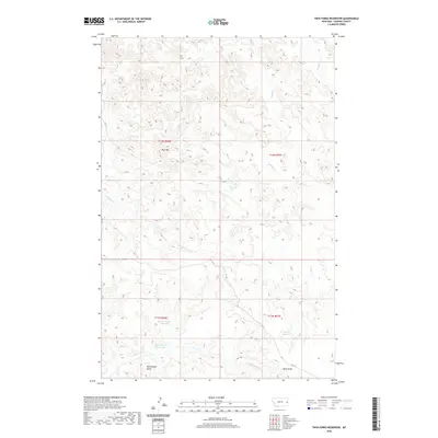
2020 Map of Twin Forks Reservoir
USGS Topo · Published 2020About this map
Twin Forks Reservoir and Upper Magpie Reservoir anchor the water management landscape of this Dawson County region. The terrain is defined by dramatic elevation changes, notably at Blue Mtn in the north and the prominent Rattlesnake Butte to the south. This area demonstrates a sophisticated irrigation and drainage network through features like the Labelle Ditch, which cuts through the southern reaches near Kelly Draw. The natural drainage is dictated by seasonal watercourses, including Magpie Cr, Frank Cr, and Glendive Cr, which carve through the high plains. A single primary road, RD 114, provides the only major vehicle access through this remote portion of eastern Montana, illustrating the sparse settlement patterns typical of the state's rugged rangelands.
Find a feature on this map
15 named features on this map. Tap any name to fly to it.
Don’t see what you’re looking for? This feature index may not catch every label — zoom into the map to look around manually.
Map Details
Editions of this 2020 Twin Forks Reservoir Map
This is the sole edition of this map. No revisions or reprints were ever made.
Other maps of this area

1909 · Glendive
USGS Topo · 1:250,000

1953 · Miles City
USGS Topo · 1:250,000

1954 · Glendive
USGS Topo · 1:250,000

1957 · Miles City
USGS Topo · 1:250,000

1957 · Glendive
USGS Topo · 1:250,000

1958 · Miles City
USGS Topo · 1:250,000

1958 · Glendive
USGS Topo · 1:250,000
1967 · Allard
USGS Topo · 1:24,000
1967 · Glendive
USGS Topo · 1:24,000
1967 · Upper Magpie Reservoir
USGS Topo · 1:24,000