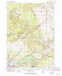
1958 Map of Twin Lake
USGS Topo · Published 1971About this map
Manistee National Forest and the Muskegon State Game Area dominate the landscape of this mid-century Michigan map, which details a rural environment defined by dozens of small glacial lakes and a dense network of country schools. The area's social geography is mapped through neighborhood landmarks such as Hazel Grove Sch, Reeths-Puffer Sch, and Dalson Sch, reflecting the decentralized community structure of the late 1950s.
Find a feature on this map
114 named features on this map. Tap any name to fly to it.
Don’t see what you’re looking for? This feature index may not catch every label — zoom into the map to look around manually.
Map Details
Editions of this 1958 Twin Lake Map
3 editions found

Other maps of this area

1929 · Montague
USGS Topo · 1:48,000

1930 · Lake Harbor
USGS Topo · 1:48,000

1930 · Muskegon
USGS Topo · 1:62,500

1931 · Hart SE
USGS Topo · 1:31,680

1931 · Walkerville SW
USGS Topo · 1:31,680

1931 · Walkerville SE
USGS Topo · 1:31,680

1936 · Muskegon
USGS Topo · 1:62,500

1936 · Lake Harbor
USGS Topo · 1:62,500

1945 · Ravenna
USGS Topo · 1:62,500

1954 · Milwaukee
USGS Topo · 1:250,000