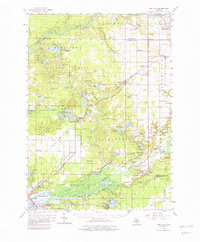
1958 Map of Twin Lake
USGS Topo · Published 1982About this map
Manistee National Forest covers much of this landscape, where the White River winds through the northern townships of Blue Lake and Holton. In the late 1950s, the region was defined by its scattered rural institutions, from the Big Blue Lake Chapel to numerous small schoolhouses like Ryerson Sch and Maple Island Sch. The Chesapeake and Ohio railroad serves as a primary transit corridor, connecting the settlements of Brunswick and Holton while passing near the Lookout Tower located south of Twin Lakes.
Find a feature on this map
113 named features on this map. Tap any name to fly to it.
Don’t see what you’re looking for? This feature index may not catch every label — zoom into the map to look around manually.
Map Details
Editions of this 1958 Twin Lake Map
3 editions found

Other maps of this area

1929 · Montague
USGS Topo · 1:48,000

1930 · Lake Harbor
USGS Topo · 1:48,000

1930 · Muskegon
USGS Topo · 1:62,500

1931 · Hart SE
USGS Topo · 1:31,680

1931 · Walkerville SW
USGS Topo · 1:31,680

1931 · Walkerville SE
USGS Topo · 1:31,680

1936 · Muskegon
USGS Topo · 1:62,500

1936 · Lake Harbor
USGS Topo · 1:62,500

1945 · Ravenna
USGS Topo · 1:62,500

1954 · Milwaukee
USGS Topo · 1:250,000