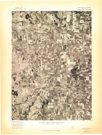
1976 Map of Twin Lake NE
USGS Topo · Published 1976About this map
Holton and Brunswick anchor this mid-1970s orthophotoquad, which provides a direct aerial perspective of the rural landscape in the Twin Lake Northeast area. Unlike traditional line-drawn maps, this image captures the exact distribution of agricultural fields, woodlots, and road networks as they existed in May 1976. The settlement of Reeman is visible in the eastern portion of the quadrangle, illustrating the small-town clusters and dispersed farmsteads characteristic of this region. The orthophoto reveals the precise geometric patterns of land use and the density of the forest canopy, offering local historians a clear record of property development and the natural environment before decades of subsequent growth and reforestation altered these clearings.
Find a feature on this map
3 named features on this map. Tap any name to fly to it.
Don’t see what you’re looking for? This feature index may not catch every label — zoom into the map to look around manually.
Map Details
Editions of this 1976 Twin Lake NE Map
This is the sole edition of this map. No revisions or reprints were ever made.
Other maps of this area

1931 · Walkerville SW
USGS Topo · 1:31,680

1931 · Walkerville SE
USGS Topo · 1:31,680

1954 · Milwaukee
USGS Topo · 1:250,000

1954 · Midland
USGS Topo · 1:250,000

1958 · Midland
USGS Topo · 1:250,000

1958 · Milwaukee
USGS Topo · 1:250,000

1958 · Hesperia
USGS Topo · 1:62,500

1958 · Twin Lake
USGS Topo · 1:62,500

1958 · Fremont
USGS Topo · 1:62,500

1959 · Midland
USGS Topo · 1:250,000