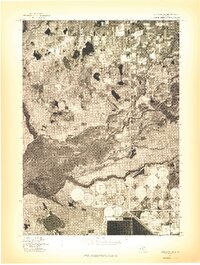
1976 Map of Twin Lake SE
USGS Topo · Published 1976About this map
The Muskegon River winds through this 1976 orthophotoquad, revealing the complex hydraulic and agricultural landscape of central Michigan just east of Muskegon. This advance print, based on aerial photography from May 1976, provides a rare visual record of land use patterns before later suburban development. The most striking visual element is the extensive network of center-pivot irrigation circles in the southeastern quadrant, which stand in sharp contrast to the dense woodlands and wetlands surrounding the river corridor. To the southwest, Wolf Lake borders the burgeoning residential footprint of the era, while the northern half of the sheet shows a patchwork of established farmsteads and rural roads. The high-resolution imagery allows for a direct study of the terrain's drainage and vegetation at a specific moment in the mid-1970s.
Find a feature on this map
2 named features on this map. Tap any name to fly to it.
Don’t see what you’re looking for? This feature index may not catch every label — zoom into the map to look around manually.
Map Details
Editions of this 1976 Twin Lake SE Map
This is the sole edition of this map. No revisions or reprints were ever made.
Other maps of this area

1930 · Muskegon
USGS Topo · 1:62,500

1936 · Muskegon
USGS Topo · 1:62,500

1945 · Ravenna
USGS Topo · 1:62,500

1954 · Milwaukee
USGS Topo · 1:250,000

1954 · Midland
USGS Topo · 1:250,000

1958 · Midland
USGS Topo · 1:250,000

1958 · Milwaukee
USGS Topo · 1:250,000

1958 · Twin Lake
USGS Topo · 1:62,500

1958 · Fremont
USGS Topo · 1:62,500

1959 · Midland
USGS Topo · 1:250,000
Featured Places
- Wolf Lake, MI
- Egelston Township, MI
- Cedar Creek Township, MI
- Moorland Township, MI
- Bridgeton Township, MI