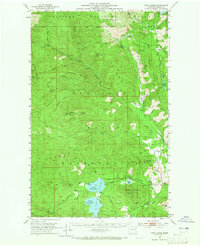
1952 Map of Twin Lakes
USGS Topo · Published 1965About this map
The Colville Indian Reservation and Colville National Forest dominate this 1952 field-checked survey of Ferry County. The landscape is defined by the prominent basins of North Twin Lake and South Twin Lake, which are connected to a network of drainages including Stranger Creek and Cornstalk Creek. Settlement patterns are distinctly rural, marked by isolated ranching sites such as the Chief Barnaby Ranch and Nicolas Ranch, alongside the small community of Meteor.
Find a feature on this map
66 named features on this map. Tap any name to fly to it.
Don’t see what you’re looking for? This feature index may not catch every label — zoom into the map to look around manually.
Map Details
Editions of this 1952 Twin Lakes Map
2 editions found

Other maps of this area

1904 · Republic
USGS Topo · 1:125,000

1936 · Marcus
USGS Topo · 1:96,000

1942 · Marcus
USGS Topo · 1:125,000

1948 · Republic
USGS Topo · 1:62,500

1948 · Sherman Peak
USGS Topo · 1:62,500

1948 · Kettle Falls
USGS Topo · 1:62,500

1948 · Hunters
USGS Topo · 1:62,500

1948 · Wilmont Creek
USGS Topo · 1:62,500

1950 · Wilmont Creek
USGS Topo · 1:62,500

1950 · Hunters
USGS Topo · 1:62,500